Pudukkottai, located in Tamil Nadu, is a heritage-rich district known for its ancient temples, natural caves, historical architecture, and traditional Tamil culture. This guide provides complete information about navigating the city, key attractions, transportation options, and how to use a tourist map effectively during your visit.
1. Overview of Pudukkottai
Pudukkottai is both a town and the administrative headquarters of the Pudukkottai district. It lies about 400 km south of Chennai and is well connected by road and rail to major cities such as Tiruchirappalli (Trichy), Madurai, and Thanjavur.
The district is famous for its cave temples, Chola-era architecture, and serene countryside.
District Area: Approximately 4,600 sq. km
Languages Spoken: Tamil (widely spoken), English (basic understanding in tourist areas)
Best Visiting Months: November to February (pleasant weather)
2. Understanding the Tourist Map
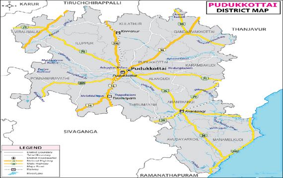
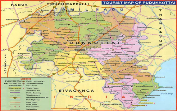
A tourist map of Pudukkottai typically highlights the following:
- The main town area and surrounding villages
- Major roads and highways (Thirumayam Road, East Main Road, West Main Road, Subramaniapuram Road, etc.)
- Key transportation hubs such as Pudukkottai Railway Station, New Bus Stand, and Old Bus Stand
- Nearby tourist attractions such as Sittanavasal Caves, Avudaiyarkoil Temple, Viralimalai Hill Temple, and Thirumayam Fort
- Local amenities like hospitals, police stations, petrol stations, and hotels
Understanding this layout helps travellers plan routes between attractions efficiently and explore both urban and rural heritage zones.
3. How to Use the Tourist Map
- Mark Your Stay:
When you arrive, locate your hotel or homestay on the map and mark it as your “Base Point.” - Plan a Day Route:
Group nearby attractions together. For example, you can visit Sittanavasal Caves, Kudumiyanmalai Temple, and Narthamalai Sculptures in a single route as they fall in the same direction. - Understand Directions:
Most tourist maps are oriented with North at the top. Use a compass app or signboards to align yourself correctly. - Offline Use:
Download or print a color copy of the map before traveling — useful when mobile data signals are weak in rural zones.
4. Main Tourist Attractions Shown on the Map
1. Sittanavasal Cave Temple:
A 2nd-century Jain cave temple famous for its rock-cut architecture and ancient fresco paintings.
2. Avudaiyarkoil (Tiruperunthurai):
A Shiva temple known for intricate stone carvings and a unique deity representation — a must-visit for art lovers.
3. Thirumayam Fort:
A historic fort built by the Sethupathi kings, offering panoramic views of the surrounding plains.
4. Viralimalai Murugan Temple:
Located atop a small hill, this temple provides scenic views and a spiritual experience.
5. Kudumiyanmalai Temple:
An architectural marvel dedicated to Lord Shiva, known for its musical inscriptions and rock-cut shrines.
6. Narthamalai Rock-Cut Temples:
A group of ancient temples with intricate Chola-era sculptures, ideal for heritage enthusiasts.
7. Government Museum, Pudukkottai:
Displays ancient coins, sculptures, and cultural artifacts from the region’s long history.
8. Avur Church:
A 17th-century Jesuit church that stands as a symbol of early European influence in Tamil Nadu.
9. Sri Kokarneswarar Temple:
One of the oldest temples in Pudukkottai, reflecting early Pandya architectural design.
10. Jambunathaswamy Temple, Thiruvandipuram:
Renowned for its massive gopuram (temple tower) and spiritual importance.
5. Transport and Connectivity
By Air:
The nearest airport is Tiruchirappalli International Airport (approximately 55 km away). From there, taxis and buses are available to reach Pudukkottai.
By Train:
Pudukkottai Railway Station is centrally located and connects to Trichy, Madurai, and Chennai. Trains operate regularly throughout the day.
By Bus:
Tamil Nadu State Transport Corporation (TNSTC) buses and private services connect Pudukkottai to all nearby towns. The New Bus Stand handles intercity routes, while the Old Bus Stand serves local and short-distance buses.
By Road:
The district is well connected by National Highway 210. Rental cars and auto-rickshaws are easily available for local travel.
6. Using the Map for Sightseeing Routes
Route 1 – Heritage Circuit:
Pudukkottai Town → Sittanavasal Caves → Kudumiyanmalai → Narthamalai → Return to Town
Route 2 – Religious Circuit:
Pudukkottai Town → Viralimalai Temple → Avudaiyarkoil → Kokarneswarar Temple → Return
Route 3 – Culture & Museum Circuit:
Government Museum → Avur Church → Local Handicraft Market → Town Restaurants
By planning these circuits using the map, visitors can cover most major attractions within two to three days.
7. Local Facilities and Landmarks on the Map
- Hospitals: Government Medical College Hospital, Janani Hospital, and others.
- Police Stations: Pudukkottai Town Police Station (near East Main Road).
- Fuel Stations: Indian Oil and HP Petrol Bunks on Thirumayam Road and Trichy Road.
- Hotels: Rasi Lodge, Hotel Subhalakshmi Palace, and Sathyam Grand Hotel are marked in central areas.
- Shopping & Dining: East Main Street, Bazaar Street, and West Main Road are key zones for markets, local eateries, and souvenir shopping.
8. Safety and Practical Advice
- Always carry a physical copy of the map or keep it saved offline on your mobile.
- Mark the emergency contact numbers:
- Police: 100
- Ambulance: 108
- Fire Service: 101
- Avoid isolated roads after 9 PM, especially in rural outskirts.
- Use official taxi stands or pre-paid autos for safety.
- During temple visits, carry a bottle of water and follow dress codes (covered shoulders and knees).
9. Map Reading Tips for First-Time Visitors
- Legend: Understand the symbols used for temples, forts, roads, and rivers.
- Scale: Use the scale bar to estimate travel distances between sites.
- Landmarks: Use major temples and markets as navigation points — locals can guide you from there.
- Local Directions: Tamil people are friendly and helpful; you can show your map and ask, “Idhu enga?” (Where is this?) for assistance.
10. Summary for Tourists
- Pudukkottai is an ideal mix of history, spirituality, and rural charm.
- The tourist map covers all important areas: transportation, landmarks, temples, and nearby villages.
- The town is compact, making it easy to explore by auto-rickshaw or taxi.
- For a complete experience, spend at least two full days in Pudukkottai — one day for heritage sites, another for temples and local markets.
- Carry water, light snacks, and sunscreen when touring during the day.